News
CARIS launches Spatial Fusion® Enterprise 5.4 with OGC® Web Coverage Services
 The latest release of Spatial Fusion Enterprise is building on its support of Open Geospatial Consortium (OGC) standards by implementing the Web Coverage Service (WCS) standard for bathymetric data. This is a continuation of CARIS’ commitment to provide organizations with the latest technology for delivering their geospatial information on the Web.
WCS is an OGC standard for downloading coverages of gridded and point cloud data. This will allow CARIS’ marine clients to share their bathymetric data through data downloads in 32-bit GeoTIFF, BAG and XYZ formats.
The inclusion of WCS is seen as the next logical step in the development of Spatial Fusion Enterprise, and follows the successful implementation of other OGC standards for viewing, querying and downloading, including Web Map Services (WMS), Web Map Tile Services (WMTS) and Web Feature Services (WFS).
Kevin Wilson, strategic accounts manager at CARIS, confirmed the positive effects being seen by users of the product, "It is important to many of our marine clients that they are able to easily share their bathymetric data on the web with stakeholders. We are now seeing more and more of our progressive clients, such as France’s Service Hydrographique et Oceanographique de la Marine and Belgium’s Vlaamse Hydrographie, utilizing the opportunity provided by Spatial Fusion Enterprise to comply with their INSPIRE responsibilities."
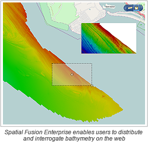
Spatial Fusion Enterprise is the final component of CARIS’ unique Ping-to-Chart™ solution. This solution allows for increases in efficiencies and seamless interoperability through the entire hydrographic workflow from hydrographic data processing to the capability, using Spatial Fusion Enterprise, to distribute and interrogate bathymetry on the web.
For more information on the Spatial Fusion Enterprise solution please visit:
http://www.caris.com/products/sfe/.
Join our Mailing List
Subscribe to email announcementsOur Latest Tweets
Tweets by Teledyne CARIS Follow us on TwitterConnect With Us

