News
LiDAR testing in BASE Editor
 The CARIS Canada technical support team recently got their hands on a Dynascan portable LiDAR system. The LiDAR was kindly loaned to CARIS by MosaicHydro of Vancouver, BC, Canada. The LiDAR was mounted on the roof rack of an SUV and was positioned using a GPS base station provided by Genivar of Fredericton, NB, Canada.
This presented a great opportunity for the CARIS team to get familiar with this equipment and figure out the workflows for getting the LiDAR data into CARIS software.
Jeremy Nicholson the Customer Services Manager commented that "Laser scanners and LiDAR systems are being increasingly used by CARIS customers, especially to map the land-sea interface, so it's important that we fully understand the workflows.”
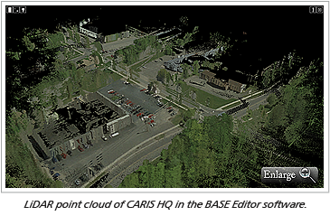
The data was imported into the BASE Editor and the Subset Editor tool was used to perform quality control and data cleaning. The data was then opened in the 3D window and draped with aerial photographs of the area.
CARIS will be continuing to expand the support of laser data in its products.
Join our Mailing List
Subscribe to email announcementsOur Latest Tweets
Tweets by Teledyne CARIS Follow us on TwitterConnect With Us

