News
Download the latest version of CARIS' freeware viewer for 2-D and 3-D data
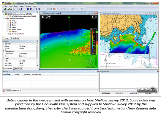
CARIS announces the release of CARIS Easy View 4.0, a freeware data viewer for 2-D and 3-D data. CARIS Easy View 4.0 replaces the popular CARIS Easy View 2.0 which has been downloaded by thousands of professionals and students. CARIS Easy View allows users to view spatial data from a wide range of file formats without the need for specialized software. For the first time CARIS Easy View is available for download in both 32 and 64-bit versions.
In this latest version, support for a number of new raster and vector file formats has been added or enhanced, including support for BAG v1.4 format. This allows users to display a wide range of publically available sources of data including topographic maps, bathymetric grids, point clouds, and raster and vector nautical charts. In addition, reference models created in the CARIS Engineering Analysis Module can now be opened directly in CARIS Easy View.
A new command in CARIS Easy View also allows users to create images in GeoTIFF, PNG, TIF and KMZ formats. Images created as GeoTIFF and KMZ are georeferenced and can easily be brought into other geospatial software systems such as CARIS BASE Editor or Google Earth™.
CARIS Easy View gives users control of the data. Users can load multiple raster, point cloud and vector data sources, change the order in which they're drawn, and adjust each layer's display parameters. CARIS Easy View also allows users to make selections and query 2-D layers. Using the 3-D visualization engine, users can fly-through the data and even create a digital AVI video. Users can effectively inspect data in the 3-D environment using various visualization, surface draping and filtering techniques.
Download the latest version of CARIS Easy View today!
Join our Mailing List
Subscribe to email announcementsOur Latest Tweets
Tweets by Teledyne CARIS Follow us on TwitterConnect With Us


